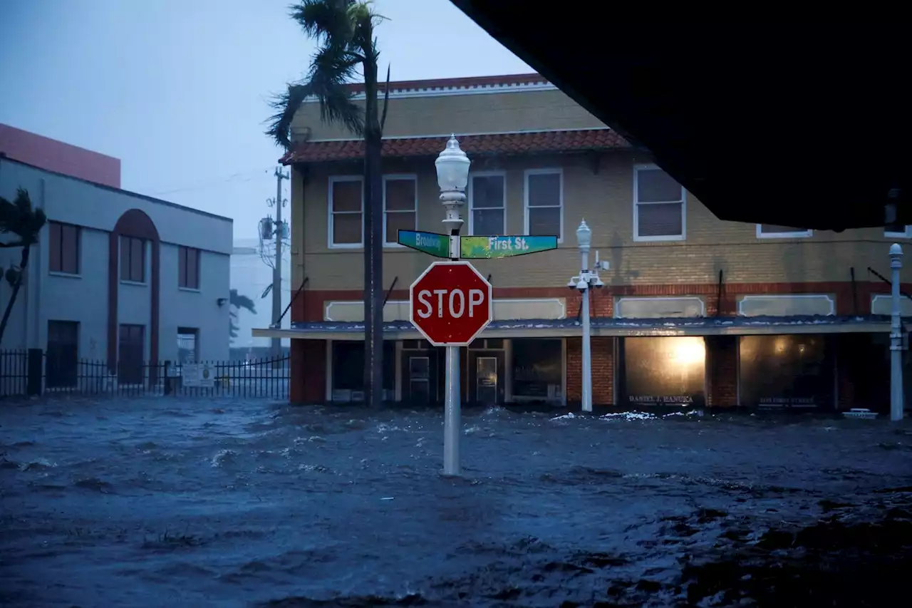
Hurricane Ian made landfall in Southwest Florida, but it was so powerful that it also caused a devastating impact a couple hundred miles away in Daytona. Footage released by Daytona Beach Police shows massive flooding in a Daytona neighborhood.
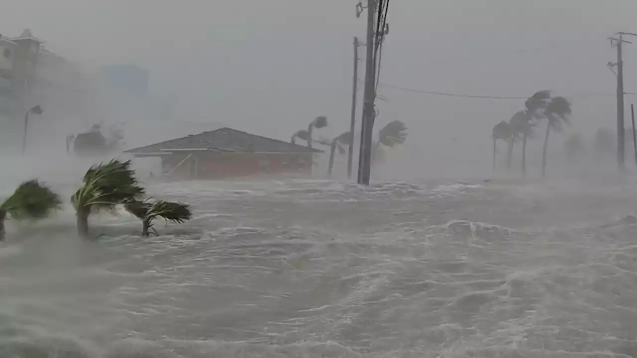
Kevin Guthrie, director of Florida's Division of Emergency Management, said there have been more than 700 rescues so far in the state in the aftermath of Hurricane Ian.
Guthrie said they are still in"hasty search" mode, while the governor said there are more than 1,000 rescue personnel going up and down the Florida coast. The emergency response to the situation has been a"herculean effort" as communities continue to suffer, said Florida Gov. Ron DeSantis. Guthrie said officials have confirmed a storm-related death in Polk County. Twenty other deaths have been reported, he said, but they are awaiting medical examination to determine if they were storm-related. Those include 12 deaths in Charlotte County and eight in Collier County.He also described a specific harrowing scene in a location that was not specified, of a completely flooded house with what is believed to be bodies inside.
"The water was up over the rooftop. But we had a Coast Guard rescue swimmer swim down into it and he could identity there appeared to be human remains. We do not know exactly how many," Guthrie said."We do not know what the situation is. And before we comment on that - we want to be transparent - but we just don't know that number."Rescue teams need the water to recede and are awaiting special equipment to investigate those situations further.
Argentina Últimas Noticias, Argentina Titulares
Similar News:También puedes leer noticias similares a ésta que hemos recopilado de otras fuentes de noticias.
 Hurricane Ian live updates: Ian downgraded to tropical storm; over 2.5M lose power in FloridaIan weakens to tropical storm as 2.5M lose power in Florida. Virginia, Georgia, Carolinas under states of emergency. Follow coverage.
Leer más »
 Hurricane Ian live updates: Hundreds of rescues in Florida as Ian eyes CarolinasLATEST: City of Sanibel officials said Thursday evening they have confirmed at least two fatalities. This brings the overall death toll from Ian to at least 11 that have been confirmed so far.
Leer más »
 Hurricane Ian live updates: Ian makes landfall in South Carolina two days after first hitting FloridaIan made its second landfall near Georgetown, S.C. as a Category 1 hurricane on Friday afternoon.
Leer más »
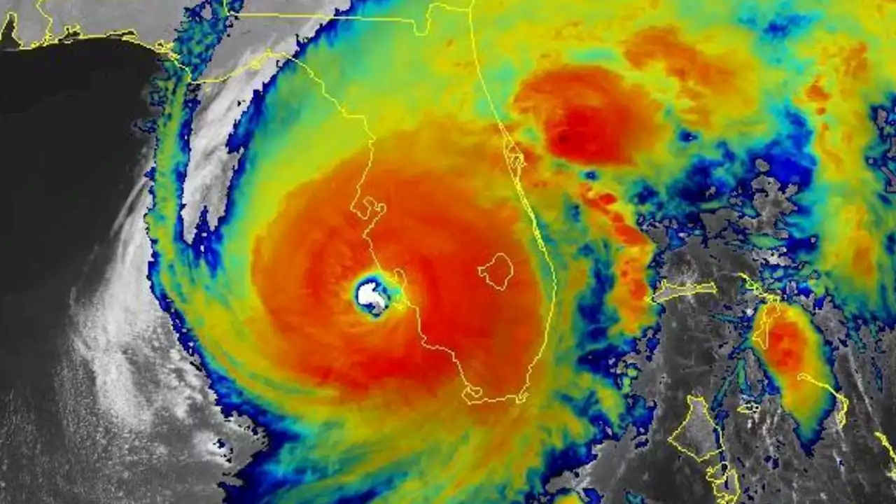 Hurricane Ian: Here's how an 'eyewall replacement cycle' turned Ian from a mess into a monsterLate Tuesday, Ian underwent what meteorologists call an eyewall replacement cycle, where the spiraling storm center contracts under intense pressure until it can no longer take the burden and collapses.
Leer más »
 Hurricane Ian: Manatees at Spring Park fighting Hurricane Ian storm surge* LOCATIONS AFFECTED\n- Bonaire\n- Centerville\n- Clinchfield\n- Elberta\n- Elko\n- Grovania\n- Grove Park\n\n* WIND\n- LATEST LOCAL FORECAST: Below tropical storm force wind\n- Peak Wind Forecast: 15-25 mph with gusts to 45 mph\n\n- THREAT TO LIFE AND PROPERTY THAT INCLUDES TYPICAL FORECAST\nUNCERTAINTY IN TRACK, SIZE AND INTENSITY: Potential for wind 39\nto 57 mph\n- The wind threat has remained nearly steady from the\nprevious assessment.\n- PLAN: Plan for hazardous wind of equivalent tropical storm\nforce.\n- PREPARE: Remaining efforts to protect property should be\ncompleted as soon as possible. Prepare for limited wind\ndamage.\n- ACT: Move to safe shelter before the wind becomes hazardous.\n\n- POTENTIAL IMPACTS: Limited\n- Damage to porches, awnings, carports, sheds, and unanchored\nmobile homes. Unsecured lightweight objects blown about.\n- Many large tree limbs broken off. A few trees snapped or\nuprooted, but with greater numbers in places where trees\nare shallow rooted. Some fences and roadway signs blown\nover.\n- A few roads impassable from debris, particularly within\nurban or heavily wooded places. Hazardous driving\nconditions on bridges and other elevated roadways.\n- Scattered power and communications outages.\n\n* STORM SURGE\n- LATEST LOCAL FORECAST: Life-threatening storm surge possible\n- Peak Storm Surge Inundation: The potential for 4-6 feet\nabove ground somewhere within surge prone areas\n- Window of concern: through Friday evening\n\n- THREAT TO LIFE AND PROPERTY THAT INCLUDES TYPICAL FORECAST\nUNCERTAINTY IN TRACK, SIZE AND INTENSITY: Potential for storm\nsurge flooding greater than 3 feet above ground\n- The storm surge threat has remained nearly steady from the\nprevious assessment.\n- PLAN: Shelter against life-threatening storm surge of\ngreater than 3 feet above ground.\n- PREPARE: Flood preparations and ordered evacuations should\nbe complete. Evacuees should be in shelters well away from\nstorm surge flooding.\n- ACT: Remain shel
Leer más »